They Even Called It GEDI
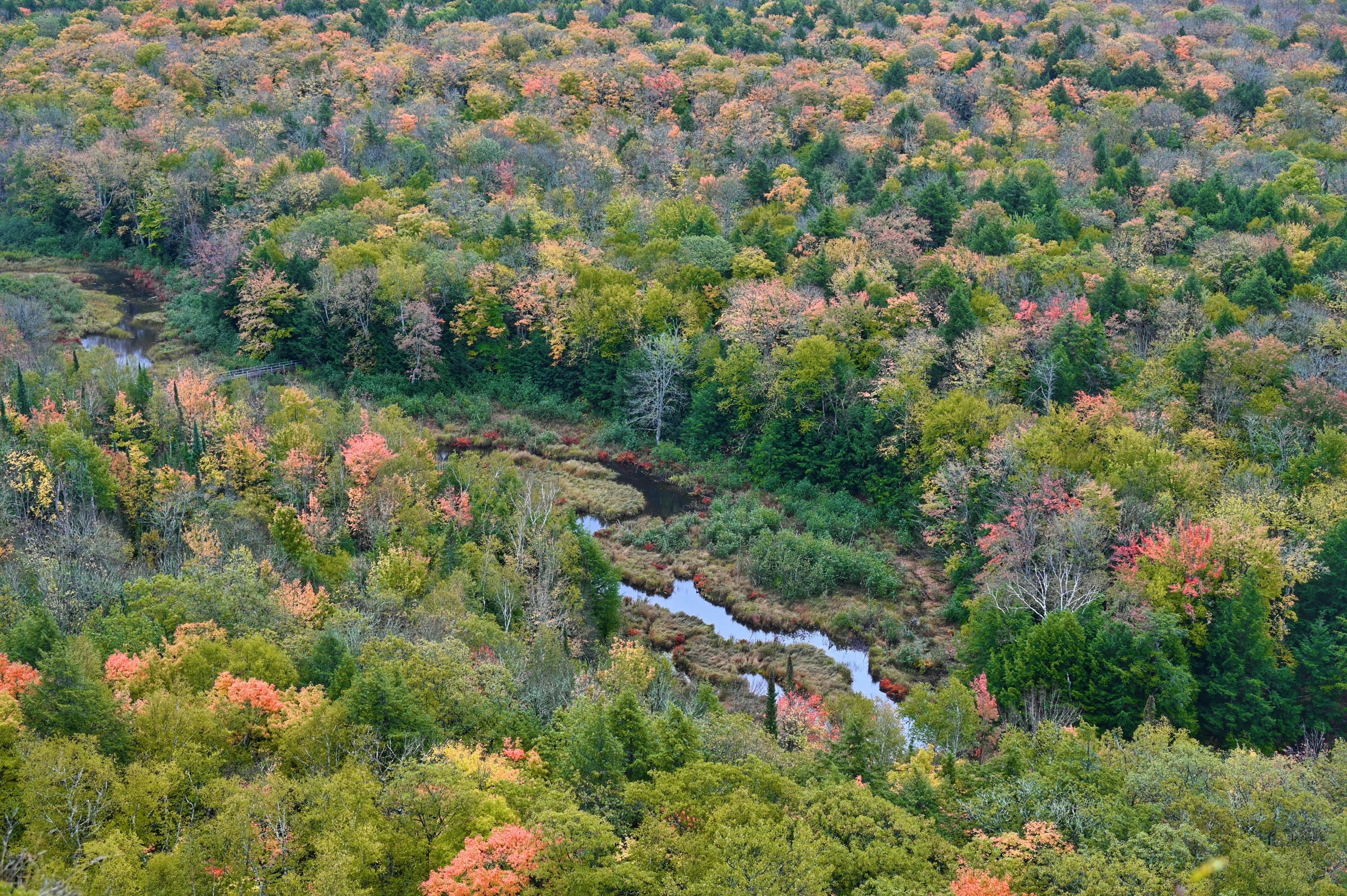
Imagine you’re hiking in the cool shade of a beech forest in the Basque Country, or that you’ve lost your way during a treasure hunt in the Amazon rainforest. With every step, you feel the power of nature, but also a limitation: from the ground, we can only see what surrounds us, trunks and leaves that hide the forest’s true magnitude.
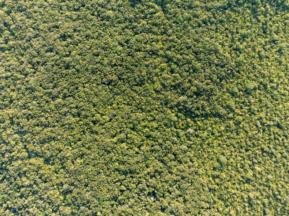
Now imagine climbing higher. From the air, no matter where you look, you see only an endless sea of green. That “roof” of vegetation, the forest canopy, hides millions of stories below: giant trees, plants, flowers, fungi, animal life, and clues about something that directly affects us all: the global carbon cycle.
Lasers to Study Forests
That’s where a fascinating tool comes into play: LiDAR, a laser-based technology capable of reconstructing the three-dimensional structure of the world around us. LiDAR is everywhere now. Even in our phones (at least the expensive ones). Autonomous vehicles use it to detect pedestrians, cyclists, and obstacles on the road. Archaeologists employ it to reveal temples and cities hidden in the jungle. Topographers rely on it to map landscapes and terrain with high precision.
The principle behind LiDAR is actually quite simple: it works by emitting laser pulses and measuring the time it takes for the reflected light to return. By doing so, it is possible to accurately determine distances, which in turn allows us to recreate the geometry of objects and surfaces in 3D.
LiDAR sensors can be mounted in a variety of vehicles. When we think about terrestrial or airborne LiDAR, the results are quite intuitive to visualize. A laser scanner mounted on a tripod, a drone, or an aircraft emits millions of pulses in many different directions. Every time a pulse encounters an object, an echo comes back to the scanner. By measuring the time between the emission of the pulse and the echo, the system calculates the exact distance between the scanner and the object that reflected the pulse. Combined with the known direction in which the pulse was emitted, it is possible to determine the exact position of the object in space. By repeating this process millions of times, LiDAR progressively produces what is known as a point cloud: a dense collection of three-dimensional points representing the scanned environment.
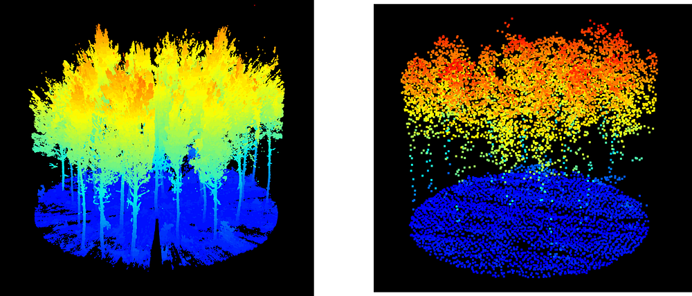
In forest ecosystems, these point clouds acquired by LiDAR can reveal trees, trunks, branches, leaves, and crowns in remarkable detail. When playing with the data, you can even walk virtually through the forest and observe its structure from any angle.
Spaceborne LiDAR Is Different
Spaceborne LiDAR, however, works differently and is therefore less intuitive to imagine. From hundreds of kilometers above Earth, satellites and orbital instruments can’t sweep landscapes with the same precision as airborne systems. Instead of generating detailed 3D point clouds, they measure something called waveforms.
A waveform can be thought of as the signature of a laser pulse interacting with the forest. When a pulse is emitted from space, it travels through the atmosphere, reaches the canopy, passes through the treetops, bounces off the ground, and returns to its point of origin, loaded with information. Indeed, fractions of the emitted pulse are reflected back at different moments depending on what they encounter along their path: some energy bounces off the tops of the trees, some from branches and leaves, and finally some reaches the ground under the vegetation.
So rather than recording the echoes of individual points, the instrument measures the amount of returned energy over time. This is what a waveform is: a one-dimensional signal describing the distribution of returned energy over time, which, in the end, describes the vegetation’s vertical structure from the top-of-canopy down to the ground.
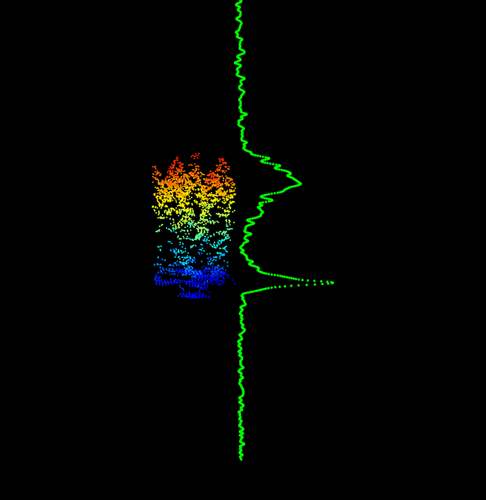
Waveform data is very valuable because it contains direct information about forest vertical structure. In theory, there is information in absolutely every aspect of this signal: the number of peaks, their width and intensity, their shape and slope, and even the distance between them. It’s like dissecting the signal looking for coded information. For example, a tall and dense tropical forest in the Amazon will produce a very different signal from a pine plantation or a sparse woodland.
Of course, spaceborne LiDAR remains less accurate than terrestrial or airborne LiDAR systems. If we could choose, it’s always better to have a point cloud than a waveform. However, a terrestrial laser scanner is a very heavy device that you need to transport in a backpack in the field. You can’t scan more than a few plots of forest before it becomes impractical. I’ve done it before, and it’s honest work. Airborne LiDAR allows us to scale up observations by mounting scanners on aircraft or drones, but these acquisitions can be expensive and remain limited in spatial coverage.
Granted, spaceborne LiDAR measurements are less detailed and more difficult to interpret, but they provide something unique: consistent observations across the entire planet. This allows for studies all over the world at many different scales. Moreover, and that’s important for researchers, the data are freely available. Of course, someone still has to pay because launching and operating a space mission costs an enormous amount of money. But this cost is absorbed by the mission agencies rather than transferred to the data users. Anyone around the world can access information about forest structure from space and study ecosystems on a global scale.
Return of the GEDI
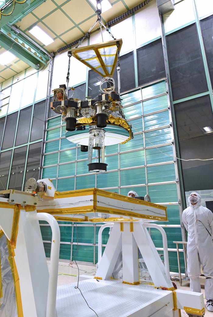
One of the most innovative space missions in this field is NASA’s GEDI (with a G, standing for Global Ecosystem Dynamics Investigation). It’s an instrument mounted on the International Space Station (ISS) that fires nearly 250 laser pulses per second toward Earth.
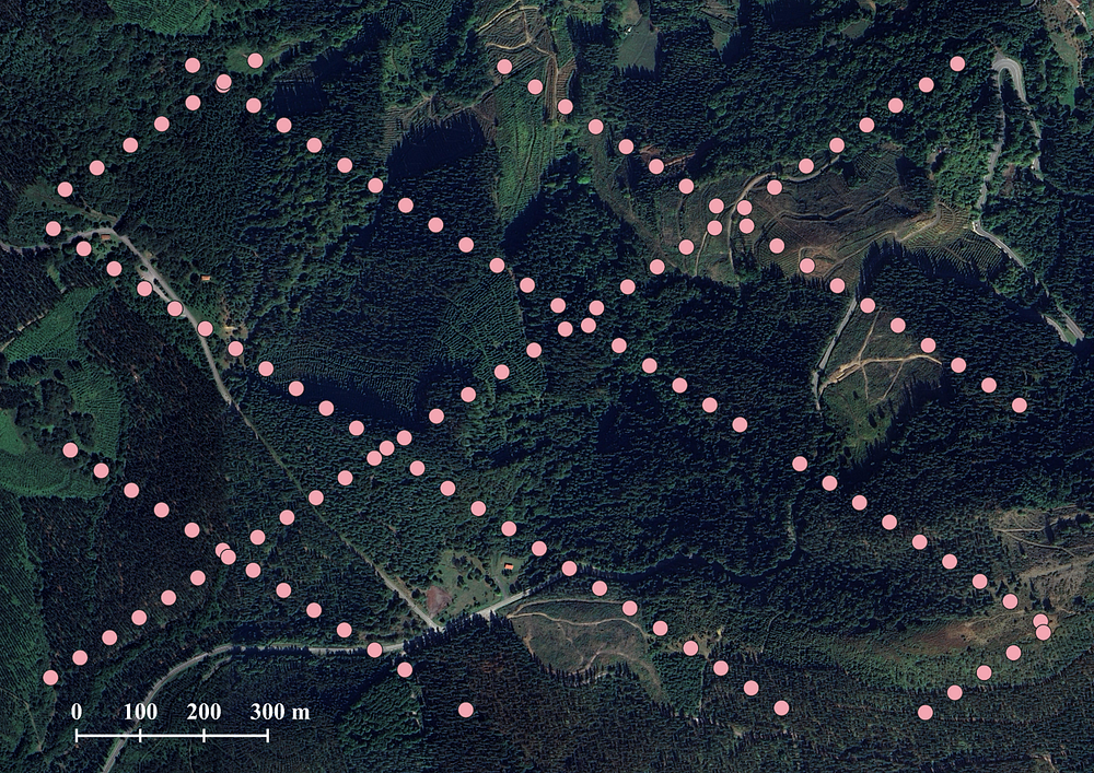
GEDI measurements are not continuous, though. This is not a limitation specific to GEDI itself, but rather to the technology: spaceborne LiDAR doesn’t produce continuous measurements over the territory. Instead, each laser pulse samples a specific circular area on the ground called a footprint. Along the ISS orbit, these footprints form tracks of observations distributed across forests around the planet. For every footprint, GEDI records a waveform describing the vertical structure of the forest at the footprint’s location.
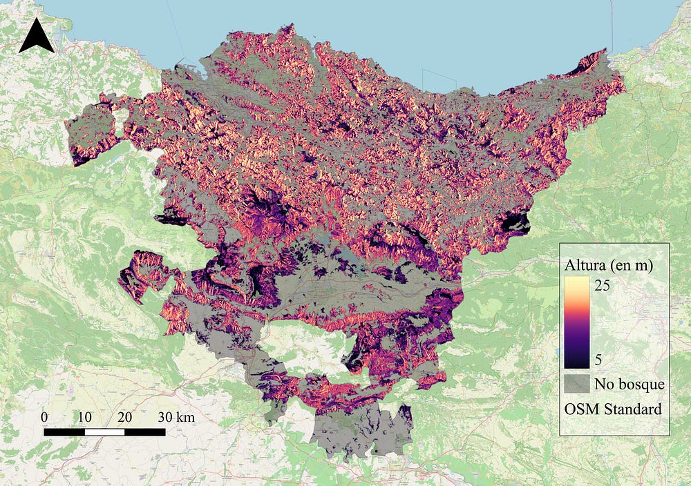
This enormous amount of collected data, in the form of millions of waveforms, enables the observation of vast forested areas for analysis on a regional, continental, and even global scale. From these measurements, scientists derive key forest variables and metrics: the height of the canopy top, the vertical distribution of foliage (i.e., the mass of leaves), and the density of vegetation at different forest layers. These parameters are then combined with field measurements into statistical models to estimate a fundamental parameter: aboveground biomass, that is, the amount of living matter contained in vegetation.
NASA shares data with the scientific community at various levels of processing: from raw waveforms to biomass products across different regions of the world. The most complete and processed product stitches together billions of individual footprint measurements into a continuous and global map of the world’s forest carbon stocks at a 1 km × 1 km cell resolution.
Why Is This Important?
Because forests, whether tropical or temperate, are the planet’s true lungs. They absorb carbon dioxide, one of the main gases responsible for climate change, and store it in the form of wood and leaves. Knowing how much biomass they contain and how it changes over time helps us better understand the role they play in regulating the global climate.
By combining spaceborne LiDAR data with other satellite imagery (both optical and radar), it is possible to obtain a much more comprehensive view of forest ecosystems: vegetation maps can be created, changes over time can be detected, and we can even anticipate how forests respond to phenomena such as droughts, fires, or human pressures. These tools have been transforming the way we study the environment, not only forests.
In the end, the real treasure isn’t hidden in some lost city in the jungle, nor beneath the roots of a centuries-old oak tree in the Basque Country, but in the forest itself. And thanks to technology, we now have the opportunity to observe it, understand it, and, above all, protect it.